
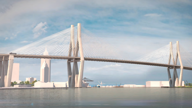
After decades of planning, the Mobile River Bridge and Bayway Project is moving forward with strong support from federal, state and local partners. The Alabama Department of Transportation (ALDOT), the Mobile Metropolitan Planning Organization (MPO) and the Eastern Shore Metropolitan Planning Organization announced a revised project approach that positions construction to begin before the end of 2026, pending anticipated approval of a federal Transportation Infrastructure Finance and Innovation Act (TIFIA) loan.
The revised approach preserves the project’s primary goal of increasing I-10 capacity across Mobile Bay while reducing overall costs through a phased construction strategy.
“This project is essential to Alabama’s future and represents one of the most important infrastructure investments in our state’s history,” Gov. Kay Ivey said. “This transformative project will strengthen our economy, improve safety and ensure we are better prepared in times of emergency.”
A Phased Approach to Move the Project Forward
Rather than constructing every component simultaneously, ALDOT has developed a two-phase plan designed to keep the project financially viable. This will also deliver meaningful traffic improvements sooner.
Phase One includes:
- Construction of a new six-lane cable-stayed bridge.
- Restriping the existing Bayway to provide six lanes of traffic across Mobile Bay.
- Improvements to major interchanges, intersections and traffic flow throughout the corridor in Mobile and Baldwin counties.
Phase Two includes:
- Construction of a new Bayway structure as additional funding becomes available, with future toll revenue helping finance the project.
Why the Project Changed
Since the project was first developed, construction costs have increased significantly because of several factors, including:
- Nationwide construction inflation
- Higher labor and material costs
- Additional engineering and geotechnical challenges on the Bayway
- Federal regulatory requirements
Updated engineering analysis determined that constructing an entirely new Bayway at the same time as the bridge would push project costs beyond a financially sustainable level. The revised phased approach allows construction to move forward while maintaining the project’s long-term vision. Phase One is currently estimated to cost approximately $3.2 billion.
Federal, State and Local Partnership
Project leaders credited months of coordination among ALDOT, the White House, the U.S. Department of Transportation, the Federal Highway Administration, Governor Ivey, Alabama’s congressional delegation and local officials for creating a viable path forward.
Recent federal actions increased flexibility in the use of funding, addressed regulatory requirements and supported financing mechanisms needed to advance construction.
Tolling Information
No tolls will be collected until the new Mobile River Bridge opens, which is currently projected around 2031. Existing toll-free routes, including the Wallace Tunnel, Bankhead Tunnel, Causeway and Africatown Bridge, will remain free.
The proposed toll options for standard vehicles include:
- $60 unlimited monthly commuter pass (about $1.36 per trip for daily commuters)
- $3 per trip with an ALGO Pass
- $7.70 per trip using a compatible interoperable transponder
- Pay-by-plate billing for drivers without a transponder
ALGO transponders are expected to be available free of charge during the initial rollout.
A Historic Investment in Alabama’s Transportation Network
The Mobile River Bridge and Bayway Project is expected to be the largest transportation infrastructure project in Alabama history. Once complete, it will improve traffic flow along I-10, enhance freight movement through the Port of Mobile, strengthen regional connectivity and improve hurricane evacuation capabilities along one of the nation’s most important interstate corridors.
What’s I-10 traffic like RIGHT NOW? I-10 Real-time traffic information for selected cities along I-10. Maps show updates on road construction, traffic accidents, travel delays and the latest traffic speeds. Traffic cameras show congestion at a glance. Visit I-10 Traffic.
The I-10 Exit Guide is the Internet’s largest and most complete website dedicated to Interstate 10 travelers. Find detailed exit service listings… lodging, camping, food, gas and more for every exit from California to Florida!
On the road? Why not take us with you. The I-10 Exit Guide is mobile-friendly and totally FREE. No App Required.
Traveling another route? Visit our growing family of exit guides: I-4 Exit Guide, I-5 Exit Guide, I-10 Exit Guide, I-75 Exit Guide, I-80 Exit Guide and I-95 Exit Guide. Detailed exit service listings… discount lodging, camping, food, gas and more for every exit along the way!