
The I-10 Mobile River Bridge and Bayway Project is one of the most ambitious infrastructure initiatives in Alabama’s history, poised to transform mobility across the Mobile River and Bay. Spanning approximately 10 miles along Interstate 10 from Virginia Street in Mobile to the US-90/US-98 interchange near Daphne, this multimodal project addresses crippling congestion, enhances hurricane resilience, and bolsters economic connectivity for the Port of Mobile and surrounding regions.1 2
Currently handling 75,000 to over 100,000 vehicles daily—more than double its original design capacity of 36,000—the existing corridor, including the aging George Wallace Tunnel and vulnerable Bayway bridges, creates bottlenecks that hinder commerce, tourism, and daily commutes.1 By introducing a new six-lane cable-stayed bridge, elevated Bayway replacements, and smart interchange upgrades, the project promises reduced travel times, safer hazardous materials routing, and elevated roadways above storm surge levels, all while incorporating modern all-electronic tolling for sustainable funding.3
As of March 2026, the project remains in preconstruction amid funding issues and delays, underscoring its critical role in Alabama’s Gulf Coast future.4
Project History
Origins and Early Planning
Discussions for expanding I-10 across the Mobile River and Bay trace back over two decades, driven by escalating traffic volumes and structural vulnerabilities exposed by hurricanes like Ivan in 2004 and Katrina in 2005. The Alabama Department of Transportation (ALDOT) identified the corridor as a chokepoint, where the Wallace Tunnel—built in the 1970s—funnels I-10 traffic into a two-lane underwater passage ill-suited for modern demands, while the Bayway’s low elevation places it in the path of storm surges.1 Initial studies in the early 2000s highlighted the need for capacity increases, hazardous materials bypasses (currently detoured via city streets), and maritime compatibility, given the Port of Mobile’s role as a vital shipping hub.2
By 2014, ALDOT released a Draft Environmental Impact Statement (DEIS), estimating costs at around $773 million for core components like a new bridge and Bayway upgrades. This phase evaluated multiple alignments, emphasizing a cable-stayed design to provide 215 feet of vertical clearance over the 600-foot-wide navigational channel, ensuring no disruption to deep-draft vessels.2 Public input shaped refinements, including bicycle and pedestrian enhancements, reflecting community priorities for accessibility to landmarks like the USS Alabama Battleship Memorial Park.
Environmental Reviews and Preferred Alternative Selection
The Supplemental DEIS (SDEIS) in 2020 marked a pivotal advancement, expanding scope to include full Bayway replacement and interchange modifications, ballooning costs to approximately $2.1 billion due to inflation, design refinements, and resilience standards (e.g., Bayway elevated for 100-year storm plus sea-level rise).2 Four build alternatives (A, B, B’, C) were assessed against the No-Build scenario. Alternative B’ emerged as preferred for its balance of engineering feasibility, minimal historic impacts (avoiding the BAE Maritime Historic District), and environmental mitigation—impacting 22.1 acres of Essential Fish Habitat (EFH) but with compensatory measures.2
Environmental justice concerns arose, particularly in Africatown, where traffic diversion to non-tolled routes like Bay Bridge Road and the Cochrane-Africatown USA Bridge could increase volumes by 4-39%, prompting mitigation via path improvements and economic development alignments.2 Wetland impacts totaled around 22 acres across alternatives, with no farmland effects in this urbanized area. The Record of Decision solidified B’ in 2020, paving the way for procurement.5
Procurement, Funding Hurdles, and Recent Milestones
ALDOT adopted a progressive design-build delivery in 2022 to accelerate progress and control costs, issuing Requests for Qualifications (RFQs) for the Mobile River Bridge and Bayway segments separately yet coordinately.4 Shortlists followed in early 2023: Kiewit | Massman | Traylor joint venture for key components, with program management by Michael Baker International and owner’s design oversight by HDR.6 3 1 Tolling procurement, essential for funding (as federal/state shares cover only partial costs), advanced with RFIs and shortlists but saw its RFP cancelled in October 2024 amid refinements.4
Funding challenges intensified as costs escalated to $3-3.7 billion due to inflation and scope expansions—nearly double ALDOT’s annual capacity budget.3 A breakthrough came in 2024-2025 with a record $550 million Bridge Investment Program (BIP) grant from the U.S. Department of Transportation, the largest ever for Alabama and second-largest nationally, earmarked primarily for the Bayway.3 Additional pursuits include public-private partnerships (P3s), bonds, and toll revenues (max $6 one-way for passenger vehicles, with frequent-user discounts). As of early 2026, collaborative tweaks have shaved tens of millions in costs and months off schedules.3
Project Features
The Iconic Mobile River Bridge
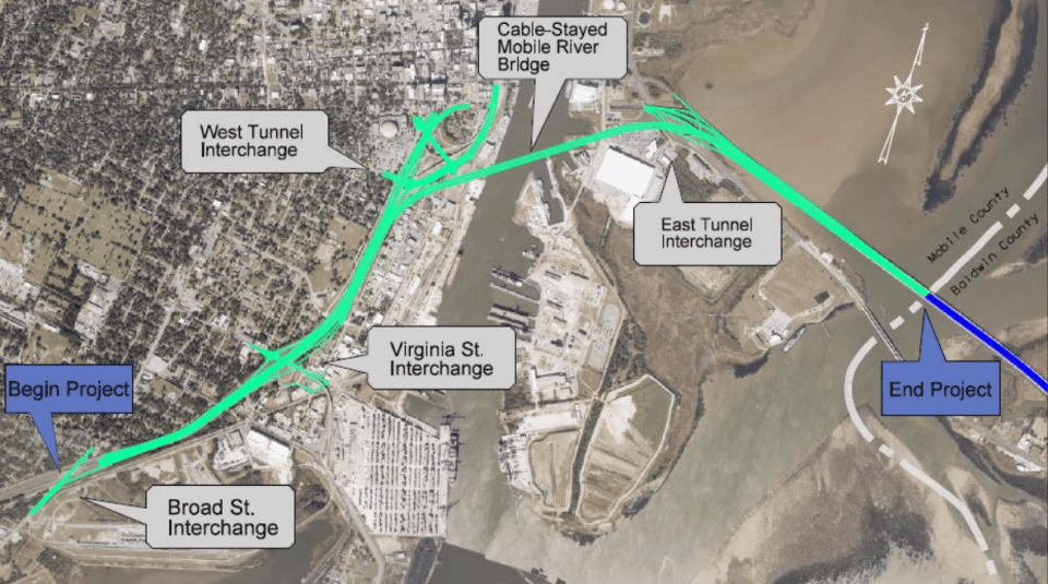
At the I-10 project’s heart is a state-of-the-art, two-tower cable-stayed bridge boasting a 2,575-foot main span—the second-highest deck over a U.S. navigable waterway after the Golden Gate—offering 215 feet of air draft to safeguard maritime operations.1 Six general-purpose lanes bypass the Wallace Tunnel, enabling hazmat trucks (hundreds daily) to traverse directly, slashing detours through downtown Mobile and Africatown. High-level approaches integrate seamlessly, with a minimum 100-year service life accounting for scour, wind, vessel collisions, and stay cable durability.6 An optional belvedere provides panoramic views, enhancing tourism appeal.2
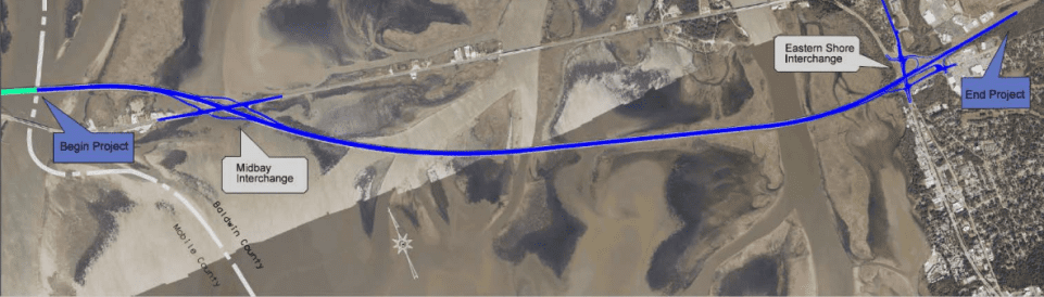
Bayway Elevations and Resilience
Positioned east of the River Bridge, the 7.4-mile Bayway replaces dual two-lane spans with two three-lane structures, elevated 8-25 feet higher—above the 100-year wave crest plus sea-level rise—to mitigate hurricane risks, as demonstrated by past closures.6 1 This low-level configuration minimizes environmental footprints while incorporating drainage, lighting, ITS (intelligent transportation systems), and utility relocations. Demolition of existing structures ensures a smoother, safer six-lane flow to the Eastern Shore.6
Interchange and Multimodal Enhancements
Seven I-10 interchanges undergo reconfiguration for high-capacity handling: Virginia Street, Canal/Water Street, US-90 East Tunnel, Mid-Bay, and US-90/98, plus ramps at East Tunnel. Features include on/off ramps, signing, barriers, and ADA-compliant bike/ped paths—preferred via Cochrane-Africatown USA Bridge shared-use path ($5.9M) with extensions ($5.1M)—fostering connectivity and equity.2
Tolling, Technology, and Sustainability
All-electronic, open-road tolling (no booths) spans Virginia Street to Daphne and tunnel approaches, segmented for equity (pay-per-use). Rates cap at $6 (2020 dollars) for cars, higher for trucks, with 15% discounts for 20+ monthly trips, generating revenue via 55-year P3 lease.2 Upgraded ITS, dredging (325,000 cy), and reduced VMT cut emissions versus No-Build, yielding $549M-$1,066M in benefits like time/fuel savings.2
Timetable and Milestones
Key Milestones Achieved
- 2014-2020: DEIS/SDEIS completion, Record of Decision (2020).2
- 2022: RFQ issuance for design-build teams.4
- 2023: Shortlists announced; tolling RFI/shortlist.4
- 2024-2025: $550M BIP grant; tolling RFP adjustments/cancellation (Oct 2024).3 4
Delays and Current Outlook
Initial targets eyed groundbreaking by late 2025 and opening in 2030, but inflation and funding complexities pushed I-10 dirt-turning to 2026.3 As of March 2026, preconstruction persists with design reviews, risk management, and federal compliance under HDR/Michael Baker oversight. Aggressive five-year construction post-NTP aims for 2031 completion, contingent on tolling finalization and additional grants.1 Optimism persists, fueled by bipartisan support and cost-saving innovations.
| Milestone | Original Target | Current Projection |
|---|---|---|
| Groundbreaking | End-2025 | 20263 |
| Construction Complete | 2030 | 2030-20313 |
| Funding Secured | Ongoing | $550M (2025); tolls/P3 pending |
Project Summary
The I-10 Mobile River Bridge and Bayway Project encapsulates visionary engineering addressing congestion, resilience, and growth in Mobile’s vital corridor. With a cable-stayed design, storm-proof Bayway, and equitable multimodal features, it forecasts Level of Service D or better by 2040, economic boosts via jobs and port access, and safer routing—benefits far outweighing costs through tolls and grants.2 Despite delays to 2026 groundbreaking amid $3B+ expenses, momentum from federal backing and expert teams signals imminent progress. Upon completion, this lifeline will propel Alabama’s Gulf economy, proving infrastructure’s power to bridge challenges and futures.
What’s I-10 traffic like RIGHT NOW? I-10 Real-time traffic information for selected cities along I-10. Maps show updates on road construction, traffic accidents, travel delays and the latest traffic speeds. Traffic cameras show congestion at a glance. Visit I-10 Traffic.
The I-10 Exit Guide is the Internet’s largest and most complete website dedicated to Interstate 10 travelers. Find detailed exit service listings… lodging, camping, food, gas and more for every exit from California to Florida!
On the road? Why not take us with you. The I-10 Exit Guide is mobile-friendly and totally FREE. No App Required.
Traveling another route? Visit our growing family of exit guides: I-4 Exit Guide, I-5 Exit Guide, I-10 Exit Guide, I-75 Exit Guide, I-80 Exit Guide and I-95 Exit Guide. Detailed exit service listings… discount lodging, camping, food, gas and more for every exit along the way!


