
Situated along the captivating coastline of Florida, the Big Bend Scenic Byway epitomizes the state’s rich tapestry of landscapes and storied past. Stretching over 220 miles, this scenic route winds through a mosaic of pristine beaches, quaint coastal towns, and untamed wilderness, offering travelers an unforgettable glimpse into the heart of Florida’s Gulf Coast region.
Exploring Nature’s Masterpiece
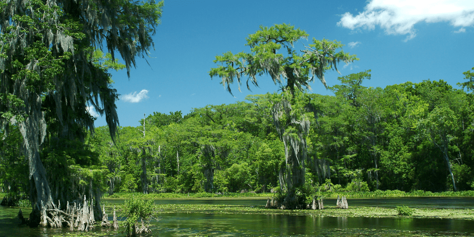
The Big Bend Scenic Byway begins its enchanting journey at the state capital, Tallahassee, where urban charm seamlessly blends with the tranquility of nature. As travelers venture westward, they are greeted by a tapestry of towering pine forests and sprawling marshlands, teeming with an abundance of wildlife. This region, known as the “Big Bend,” owes its name to the distinctive bend in Florida’s coastline, characterized by its gentle curves and unspoiled beauty.
Apalachee Bay: A Haven for Nature Enthusiasts
One of the highlights of the Big Bend Scenic Byway is its proximity to the Apalachee Bay, a pristine estuarine ecosystem renowned for its biodiversity. Here, travelers can explore the untamed wilderness of St. Marks National Wildlife Refuge, home to a myriad of bird species, including majestic bald eagles and elusive roseate spoonbills. Nature enthusiasts can embark on scenic hikes along the refuge’s tranquil trails, or paddle through the meandering waterways of the Wakulla River, immersing themselves in the serenity of the natural world.
Coastal Charms and Historic Treasures
As the byway winds its way along Florida’s Gulf Coast, travelers are treated to a treasure trove of coastal charms and historic landmarks. The quaint fishing village of Panacea beckons visitors with its laid-back atmosphere and panoramic views of the Gulf of Mexico, while the historic town of Apalachicola offers a glimpse into Florida’s storied past, with its beautifully preserved 19th-century architecture and bustling waterfront.
An Oasis of Serenity: St. George Island
No journey along the Big Bend Scenic Byway would be complete without a visit to St. George Island, a pristine barrier island renowned for its sugar-white sand beaches and emerald-green waters. Here, travelers can unwind amidst the natural splendor of Dr. Julian G. Bruce St. George Island State Park, where miles of unspoiled coastline beckon sun-seekers and nature lovers alike. From swimming and snorkeling to beachcombing and birdwatching, St. George Island offers endless opportunities for outdoor recreation and relaxation.

Preserving Florida’s Natural Heritage
The Big Bend Scenic Byway not only offers travelers a window into Florida’s natural beauty but also serves as a vital corridor for conservation and environmental stewardship. Through collaborative efforts between government agencies, conservation organizations, and local communities, initiatives such as habitat restoration, wildlife conservation, and sustainable tourism practices are helping to safeguard the region’s ecological integrity for generations to come.
Big Bend Scenic Byway Trails
Florida’s Big Bend Scenic Byway consists of two corridors, the Forest Trail and the Coastal Trail.
The Forest Trail
Back in the 1800s the Forest Trail was truly the “Wild West,” with cowboys, rustlers, Indians, trappers, and hard-scrabble farmers. Start the day walking through a pioneer farm and stop later at Fort Braden, a military outpost during the Second Seminole War. See rolling sand hills and hardwood forests give way to extensive stretches of pine forests, wetlands, and river floodplains. Come to the Apalachicola National Forest, which features the best remaining example of a native Longleaf Pine and Wiregrass ecosystem in the United States, as well as the largest population of the endangered Red-Cockaded Woodpecker. See the mysterious Dwarf Cypress Dome, where trees over 300 years old are only 6-15 feet tall.

The Forest Trail section of the byway begins on SR 65 (James Gadsden highway) at US 98/US 319/SR 30 and goes to the Apalachicola National Forest Boundary.
- Go along SR 65 and come to the Franklin/Liberty County Line.
- Continue along the Sopchoppy Highway from the line to CR 299 (Curtis Mills Road).
- Travel from US 319/SR 377 to CR 22. Along CR 22 (Rose Street) go from CR 299 to CR 375 in Sopchoppy.
- On CR 375 go form the CR 22/CR 375 intersection to Winthrop Street, then go northbound on CR 375.
- From the Wakulla/Leon County Line, go eastbound along SR 20 and go to SR 263.
- Go to SR 267 at US 98/SR 30 and go to CR 373.
- From there, go back to the Wakulla/Leon County Line and travel along Springhill Road to SR 263 (Capital Circle).
- End at SR 20 (Blountstown Highway).


The Coastal Trail
The Coastal Trail was first discovered in 1528 by Panfilo de Narvaez and was occupied by Spanish, English, American, and Confederate forces. In the 1800s, the rivers were full of ships with cotton and timber bound for foreign markets. Later they were replaced by sponge, shrimp, crab, oyster, and fishing boats, which still ply these waters. This rich heritage beckons you to explore barrier islands, sand dunes, beaches, bays, coastal marshes, and springs of the Coastal Trail. Visit the Edward Ball Wakulla Springs State Park, one of the world’s largest and deepest fresh water springs. If geology is of interest to you, the interpretive trail at Leon Sinks Geological Site is a must. Created over millions of years, its Karst Topography of mysterious underground caverns and magical subterranean lakes make this site of global scientific interest.

To travel the Coastal Trail, begin on Market Street in Apalachicola at Scipio Creek Marina.
- Continue along Market Street to US 98/SR30/Avenue E in Apalachicola.
- Go to US 98/SR 30 (John Gorrie Memorial Bridge).
- Go to CR 65 in Eastpoint.
- On CR 65 (South Bayshore Drive), go southbound to SR 300.
- On SR 300 (Island Drive) go eastbound on CR 300 (East Gorrie Drive) from SR 300 to the entrance of Dr. Julian G. Bruce St. George Island State Park.
- Continue southbound on SR 300 to the east boundary of the state park.
- Return northbound along SR 300 from CR 65 to Patton Drive.
- On Patton Drive, go to US 98/US 319/SR 30.
- Go to SR 30-A in Carrabelle.
- On CR 30-A (Gulf Avenue) go from US 98/US 319/Sr 30 to US 319/SR 377 (Sopchoppy Highway).
- Go through the Franklin/Wakulla County Line, through Panacea, past US 319/SR 375, past US 319/SR 61, to SR 363.
Conclusion: A Journey of Discovery
Florida’s Big Bend Scenic Byway is more than just a road; it’s a gateway to adventure, exploration, and discovery. From its pristine coastline to its verdant forests, this scenic route invites travelers to slow down, embrace the rhythm of nature, and immerse themselves in the timeless beauty of the Gulf Coast region. Whether you’re seeking outdoor adventure, cultural enrichment, or simply a moment of serenity amidst the chaos of modern life, the Big Bend Scenic Byway offers something for everyone—a journey of a lifetime waiting to be explored.
The I-10 Exit Guide is the Internet’s largest and most complete website dedicated to Interstate 10 travelers. Find detailed exit service listings… lodging, camping, food, gas and more for every exit from California to Florida!
On the road? Why not take us with you. The I-10 Exit Guide is mobile-friendly and totally FREE. No App Required.
Traveling another route? Visit our growing family of exit guides: I-4 Exit Guide, I-5 Exit Guide, I-10 Exit Guide, I-75 Exit Guide, I-80 Exit Guide and I-95 Exit Guide. Detailed exit service listings… discount lodging, camping, food, gas and more for every exit along the way!


